Typhoon Narra Stalls 145km East of Hai Phong, Repeatedly Shifting Direction Before Expected Weakening
Typhoon Narra stalled 145km east of Hai Phong at 4:00 AM on August 24, 2026, crawling at 3 km/h with level 9 winds before an expected weakening into a tropical depression by August 27.
Original report
www.vietnam.vn
Industry impact
Prolonged, erratic typhoon tracks over the Gulf of Tonkin force aviation and maritime operators to extend disruption planning windows well beyond a storm's initial landfall forecast.
What happened
As of 4:00 AM on August 24, 2026, the center of Typhoon Narra (Typhoon No. 4) sat in the sea northeast of Bach Long Vi Special Economic Zone, about 140 km east-southeast of Quang Ninh province and roughly 145 km east of Hai Phong city, according to Vietnam's National Center for Hydro-Meteorological Forecasting (NCHMF). The storm had moved very little over the past several hours, crawling southeast at roughly 3 km/h. Maximum sustained winds near the center reached level 9 (75–88 km/h), with gusts up to level 11.
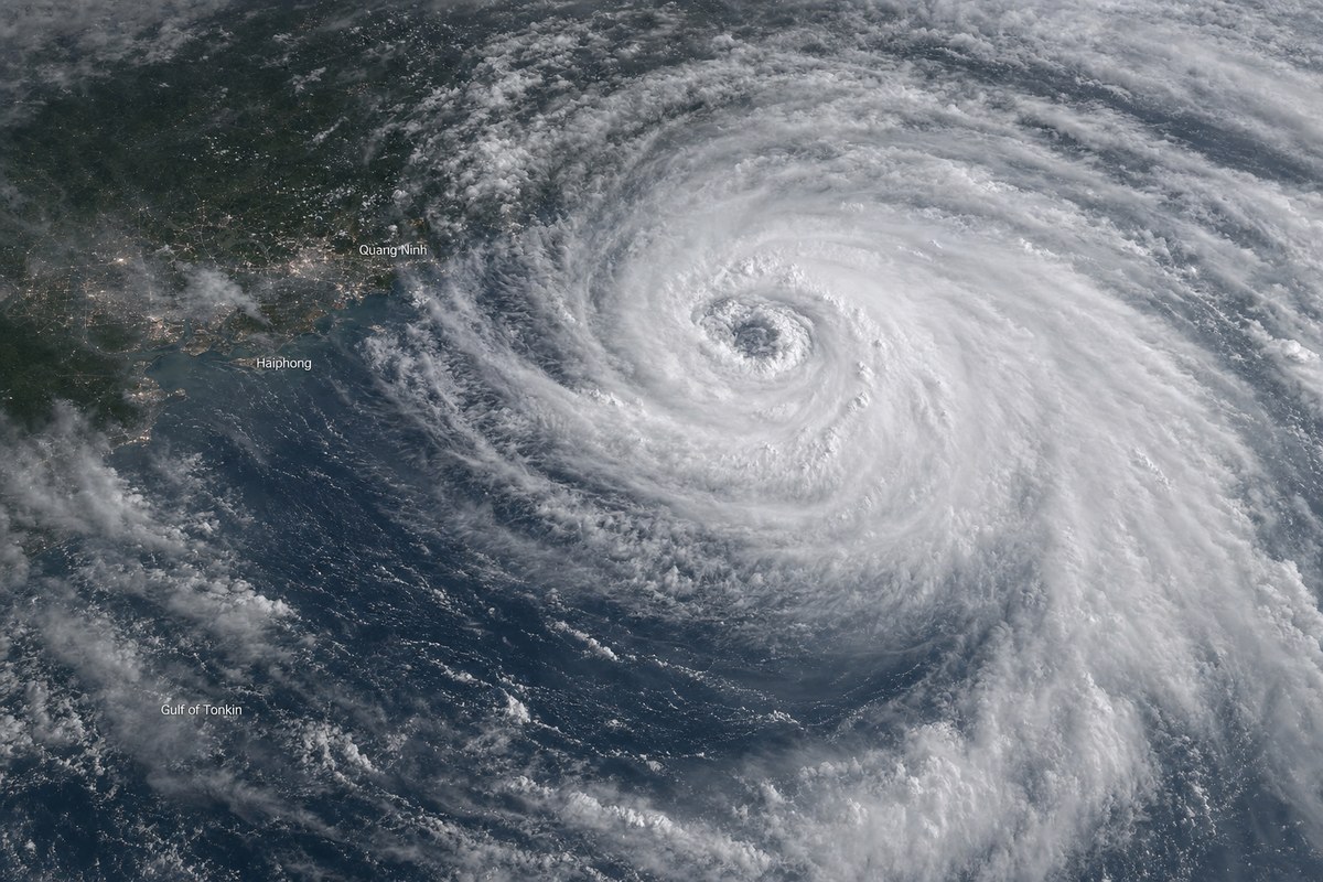
Bach Long Vi Special Zone recorded level 9 winds gusting to level 11; Co To Special Zone in Quang Ninh experienced level 6 winds gusting to level 9; Mong Cai and Uong Bi in Quang Ninh recorded level 7 and level 6 winds respectively; and Phu Lien in Hai Phong had level 7 winds gusting to level 8. Forecasters project that by 4:00 AM on August 25, the storm's center will be about 110 km east of Bach Long Vi, still at level 9 with gusts to level 11, before turning northeast to reach approximately 240 km northeast of Bach Long Vi by 1:00 PM on August 26 at level 8–9 intensity with gusts to level 10–11. It is then expected to turn north-northwest and weaken into a tropical depression, with its center forecast over southern Guangxi province, China, at level 6 intensity by 4:00 AM on August 27.
Nguyen Van Huong, Head of the Weather Forecasting Department at NCHMF, described the typhoon's trajectory as complex and unusual, attributing the erratic path to weak steering currents and multiple weather-system interactions along the tropical convergence zone. In the Gulf of Tonkin, seas near the storm's center are running 3–5 meters high. Between 7:00 PM on August 21 and 4:00 AM on August 24, widespread rainfall of 100–200 mm was recorded across the Northeast region and Thanh Hoa province, with exceptional totals at Hong Ha in Quang Ninh reaching 547 mm, Mau Son in Lang Son reaching 520 mm, and Cat Ba in Hai Phong reaching 413 mm.
How it unfolded
Industry impact & what to watch
A near-stationary storm sitting over a shipping and fishing zone for days behaves differently from a fast-moving system: it keeps hazardous sea states and gusty coastal winds in place far longer than a single-day landfall would, even while its peak intensity stays capped near level 9. NCHMF's own forecaster called the track complex and unusual, tying the stall to weak steering currents and convergence-zone interactions — a mechanism that also explains why the Gulf of Tonkin has kept 3–5 meter seas and level 6-to-8 coastal gusts across Quang Ninh and Hai Phong for an extended stretch instead of a brief squall.
Coastal and near-shore operations built around a fixed storm-passage window instead face a rolling one: fishing boats, cargo vessels, tourist boats and aquaculture facilities in the Gulf of Tonkin remain exposed until the system actually turns north-northwest and degrades to a depression over Guangxi, not until it merely passes closest approach. Rainfall totals already exceeding 500 mm at some stations add flash-flood and landslide exposure across Northern Vietnam's mountainous terrain on a separate timeline from the wind hazard itself.
The next fixed points are the two forecast positions NCHMF has published: the turn toward the northeast expected by 1:00 PM on August 26, and landfall as a weakened depression over southern Guangxi by 4:00 AM on August 27. Any further stall or renewed course change before either milestone would extend the current wind and sea-state warnings for Quang Ninh and Hai Phong beyond what is now forecast.
Who this affects
- Commercial Airports — Wind gusts up to level 8 and rain through August 25 threaten sustained disruption at airports near Hai Phong and Quang Ninh.
- Air Traffic Management (ATM) Authorities — Air-navigation and weather authorities must keep reissuing warnings as the storm's unusual, shifting track defies a single fixed forecast.
- Fuel Suppliers — Marine and coastal supply operations in the Gulf of Tonkin face days of rough seas rather than a single passing front.
The underlying facts come from the originating publisher (linked above). The narrative, industry-impact assessment and per-role analysis below are produced independently by the AVI-GO intelligence team from public information. Cite as: AVI-GO, "Typhoon Narra Stalls 145km East of Hai Phong, Repeatedly Shifting Direction Before Expected Weakening" news brief, 2026-08-25.
How to cite
AVI-GO, “Typhoon Narra Stalls 145km East of Hai Phong, Repeatedly Shifting Direction Before Expected Weakening”. https://ai.avi-go.com/news/ai-news-center/news-briefs/typhoon-narra-stalls-145km-east-of-hai-phong-repeatedly-shifting-direc-5cd99621ade2f84273ea575fa3100d6a
Figures carry an explicit measurement window — cite the window shown on this page, not the date you retrieved it.